 Date: 2014 Feb 12 22h 58m, to 2014 Feb 12 23h 7m
Occultation rasante du 12 février
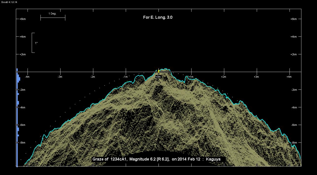
Grazing Occultation of 1234cA1 Magnitude 6.2 [Red = 6.2]
Nominal site altitude 250m
E. Longit.   Latitude     U.T.    Sun  Moon   TanZ   PA    AA      CA
   o  '  "    o  '  "   h  m  s   Alt Alt Az          o     o      o
   1  0  0   47 55 39  22 57 33       57 189  0.66  18.8   6.26  19.49N
   1 15  0   47 51  8  22 58  1       57 190  0.66  18.8   6.30  19.54N
   1 30  0   47 46 34  22 58 29       57 191  0.66  18.9   6.35  19.59N
   1 45  0   47 41 58  22 58 57       57 191  0.66  18.9   6.40  19.63N
   2  0  0   47 37 19  22 59 26       57 192  0.66  19.0   6.45  19.68N
   2 15  0   47 32 37  22 59 54       57 193  0.66  19.0   6.50  19.73N
   2 30  0   47 27 53  23  0 23       57 193  0.66  19.1   6.54  19.78N
   2 45  0   47 23  7  23  0 51       57 194  0.66  19.1   6.59  19.82N
   3  0  0   47 18 18  23  1 20       57 195  0.66  19.2   6.64  19.87N
   3 15  0   47 13 27  23  1 49       57 195  0.66  19.2   6.69  19.92N
   3 30  0   47  8 33  23  2 18       57 196  0.66  19.3   6.73  19.97N
   3 45  0   47  3 36  23  2 47       57 197  0.66  19.3   6.78  20.01N
   4  0  0   46 58 37  23  3 16       57 197  0.66  19.4   6.83  20.06N
   4 15  0   46 53 35  23  3 45       57 198  0.66  19.4   6.88  20.11N
   4 30  0   46 48 31  23  4 15       57 199  0.66  19.5   6.92  20.15N
   4 45  0   46 43 25  23  4 44       57 200  0.66  19.5   6.97  20.20N
   5  0  0   46 38 16  23  5 14       57 200  0.66  19.5   7.01  20.24N
   5 15  0   46 33  4  23  5 44       57 201  0.66  19.6   7.06  20.29N
   5 30  0   46 27 49  23  6 13       57 202  0.66  19.6   7.11  20.33N
   5 45  0   46 22 33  23  6 43       57 202  0.66  19.7   7.15  20.38N
   6  0  0   46 17 13  23  7 13       57 203  0.66  19.7   7.20  20.42N
Path coordinates are referred to WGS84 (as used by GPS), with the
nominal site altitude being referenced to Mean Sea Level.
1234 is double:
  This next pair is not confirmed
  ** 6.9 6.9 0.10" 333.0** (OCc 417) Graze path of ? 0.15 km south, and 0.2 secs earlier compared to the primary
    C A S S I N I   R E G I O N   G R A Z E
                Librations  Long +0.01   Lat +7.06
                            P +6.78     D -6.75
      Illumination of moon  96%+
        Elongation of Moon  157
    Vertical Profile Scale  2.23 km/arcsec at mean distance of moon
   Horizontal Scale Factor  1.33 deg/min
At longitude 3.50:
Limiting Magnitudes for various telescope apertures (in cm)
      CA\Tdia   5    10    15    20    25    30    35
    16.0      4.5   5.9   6.7   7.2   7.6   7.8   8.0
    18.0      4.6   6.1   6.9   7.4   7.7   8.0   8.2
    20.0      4.9   6.4   7.2   7.7   8.0   8.3   8.5
    22.0      5.3   6.8   7.5   8.1   8.4   8.7   8.9
    24.0      5.5   6.9   7.7   8.2   8.6   8.8   9.0
------------------------------------------------------------------------------
Double star catalogue details
WDS entries
  RA  Dec Name          Y1   Y2     N  PA  PA   Sep   Sep  M1    M2
08110+1438OCC 417      1975 1975    0  -1  -1   0.1   0.1  6.9   6.9            -023-017                        081058.90+143746.3
08112+1436GWP 991      1989 1997    2 214 215  13.4  12.8 12.5  17.8            +052-026 +048-034           V   081113.11+143548.4
------------------------------------------------
Interferometric catalogue entries
081058.90+143746.3  HR 3198                   OCC 417                   HD  67959    HIP  40058         08110+1438
    Date       PA              Sep                  M1             M2
  1975.      V333.      .      0.1        .         6.9     .      6.9     .                       1  OCC2002  O
  1988.168       .      .   <  0.038      .          .      .       .      .       549  22   3.6   1  McA1993  Sc
------------------------------------------------------------------------------
Results of Observer Scan                                    UT
Site                              Long.   Lat.   Dist.    h  m  s
Belgique-Marcinelle                 4.4   50.4   347km   23  4  7
France                              1.5   47.5    28km   22 58 29