Occultation rasante du 12 novembre
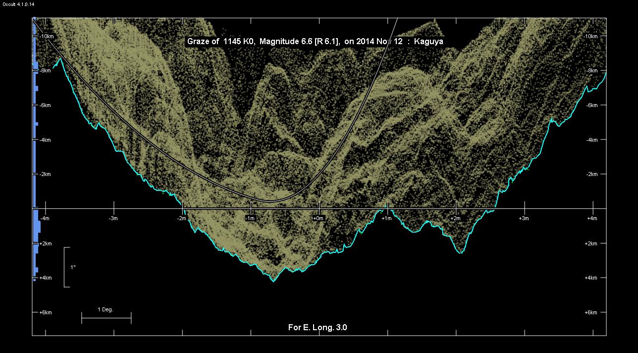
Grazing Occultation of    1145 K0      Magnitude 6.6 [Red = 6.1]
   R1145 = 67 Geminorum
Date: 2014 Nov 12  4h 27m,  to  2014 Nov 12  4h 37m
Nominal site altitude 250m
E. Longit.   Latitude     U.T.    Sun  Moon   TanZ   PA    AA      CA
   o  '  "    o  '  "   h  m  s   Alt Alt Az          o     o      o
   1  0  0   51 33  6   4 27  5       54 189  0.73 193.0 183.68   0.91S
   1 15  0   51 30  4   4 27 33       54 190  0.73 193.1 183.72   0.95S
   1 30  0   51 26 59   4 28  1       54 190  0.73 193.1 183.77   0.99S
   1 45  0   51 23 52   4 28 29       54 191  0.73 193.2 183.81   1.04S
   2  0  0   51 20 44   4 28 57       54 191  0.73 193.2 183.85   1.08S
   2 15  0   51 17 33   4 29 25       54 192  0.73 193.2 183.90   1.12S
   2 30  0   51 14 20   4 29 53       54 193  0.73 193.3 183.94   1.16S
   2 45  0   51 11  5   4 30 21       54 193  0.73 193.3 183.98   1.21S
   3  0  0   51  7 48   4 30 50       54 194  0.73 193.4 184.02   1.25S
   3 15  0   51  4 29   4 31 18       54 194  0.73 193.4 184.07   1.29S
   3 30  0   51  1  8   4 31 46       54 195  0.73 193.5 184.11   1.33S
   3 45  0   50 57 45   4 32 15       54 196  0.73 193.5 184.15   1.38S
   4  0  0   50 54 20   4 32 43       54 196  0.73 193.5 184.19   1.42S
   4 15  0   50 50 52   4 33 12       54 197  0.73 193.6 184.23   1.46S
   4 30  0   50 47 23   4 33 41       54 198  0.73 193.6 184.28   1.50S
   4 45  0   50 43 51   4 34  9       54 198  0.73 193.7 184.32   1.54S
   5  0  0   50 40 17   4 34 38       54 199  0.73 193.7 184.36   1.58S
   5 15  0   50 36 41   4 35  7       54 199  0.73 193.7 184.40   1.63S
   5 30  0   50 33  3   4 35 36       54 200  0.73 193.8 184.44   1.67S
   5 45  0   50 29 23   4 36  5       54 201  0.73 193.8 184.48   1.71S
   6  0  0   50 25 41   4 36 34       54 201  0.73 193.9 184.52   1.75S
Path coordinates are referred to WGS84 (as used by GPS), with the
nominal site altitude being referenced to Mean Sea Level.
Projected diameter of star 2 meters [Estimated]
                Librations  Long +3.94   Lat +7.27
                            P +184.65     D +7.23
      Illumination of moon  73%-
        Elongation of Moon  117
    Vertical Profile Scale  2.30 km/arcsec at mean distance of moon
   Horizontal Scale Factor  1.38 deg/min
At longitude 3.50:
Limiting Magnitudes for various telescope apertures (in cm)
      CA\Tdia   5    10    15    20    25    30    35
    -2.7      2.8   4.3   5.0   5.5   5.8   6.1   6.2
    -0.7      2.8   4.3   5.0   5.5   5.8   6.1   6.2
     1.3      2.8   4.3   5.0   5.5   5.8   6.1   6.2
     3.3      4.8   6.2   7.0   7.5   7.9   8.1   8.3
     5.3      4.8   6.2   7.0   7.5   7.9   8.1   8.3
------------------------------------------------------------------------------
Results of Observer Scan                                    UT
Site                              Long.   Lat.   Dist.    h  m  s