New features
of versions 5.52
Version 5.52b - January 18, 2008
Version 5.52 of Iris adds the possibility to read and
process RAW files from Canon EOS 40D, Nikon D3, D300 and Sony
Alpha 700 Digital SLR camera. It is also possible to remote control Canon 40D
for exposure longer than 30
seconds (directly by using USB interface, without the use of an external electronics,
see here).
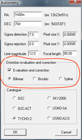
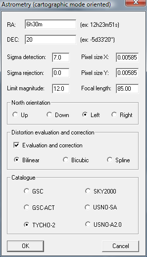
The astrometrical reduction of wide-field images is improved by taken into account of the optical disortion. The distortion can be like previously measured (then corrected) in manually mode by comparing the position of stars in the images and the position of these same stars taken in an astrometric catalog (see here). But it is now possible to find automatically distortion parameters during a first iteration of the astrometrical reduction (Iris fit observed stars and catalogue stars for the distortion solution). In a second step, Iris correct the barrel-distortion of the image and re-run a precise astrometric reduction. Dialog box Astrometry (Analyze menu) was modified to allow to calculate the disortion and correct the image geometrically (exactly as if the image were made with an optics free of distortion):
So, calculation is carried out in two steps. Step 1, a relatively coarse reduction to find a maximum of homologous stars, to calculate the parameters of distortion of order 5 (A1, A3 and A5), then to correct the geometric optical distortion. Stage 2, high precision astrometical reduction of the geometrically corrected image. The value of distortion parameters is returned at the end of calculation. The displayed image is astrometically reduced (distortion is also corrected).
The image PIC header was enriched to include astrometrical reduction parameters
and cartographic projection parameters. The PIC format structure remains unchanged in spite of this addition.
Three macrocommands were added (SV1, SV2 and SV3) for facilitate data analysis of Digital SLR in the field of survey program. Typical applications concern detection of new variable stars, novae, comets... The SVn commands are also powerful tools to carry out panorama from individual images. Connection between the images is of an astrometrical quality (for example by using the Tycho-2 catalog has reference). A particular care was taken to adjust the relative intensity level of the each frames and find a precise sky background (correction of airmass variation and vignetting). The barrel distortion produced by the camera optics is also concerned. Many cartographic projections are availables. The use of SV1, SV2 and SV3 is described in details in this downloadable PDF document (file survey_us.pdf, 8.2 Mb - english version available).

Mosaic example of 20
frames covering the area of the
Auriga-Taurus-Orion constellations.
Click here or into the image above for
display a B&W large version (4Mb file).
This enlarged version is even
a 20% reduction of the starting RAW images (90 seconds
exposure, Canon 40D
and 85 mm f/1.2 lens stopped at f/2)! The images were taken in urban environment
with a strong
parasitic background (limiting naked eye magnitude of 3 at zenith).
In spite of these difficult conditions the transition between
the individual images is satisfactory. The
top left bright object is Mars planet. The botton left bright
object is Sirius. The preprocessing, the
astrometrical reduction
and the mosaic assembling were carried out only by
using commands SV1, SV2 and SV3.
Click
here for a very large mosaic (Virgo - Pegasus region).
The autoguiding section for long slit spectrography was completed by the choice of guiding with a vertical slit and a horizontal slit.
NEWS COMMAND
CENTER
Draw un cross at the center of into the current image.
DISTANG [RA1] [DEC1] [RA2] [DEC2]
Return the angular distance between two points (ra1, dec1) and (ra2, dec2) of celestial sphere. Example:
>distang 12h32m 23d40' 12h25m11s 23d46'20"
INFO_ASTRO
Return infos about astrometical reduction and cartographic projection of the current images.
GC [AD1] [DEC1] [AD2] [DEC2]
Draw a great cercle between two points with equatorial coordinates (ra1, dec1) et (ra2, dec2) - after astrometric reduction of course. Example :
>gc 12h32m 23d40' 12h25m11s 23d46'20"
RESET_ASTRO
Erase all informations related to astrometric solution into the current image.
SV0 [FILE NAME]
Run a script file (.lst extension) for develop sequence of RAW DSRL images and compute a full preprocessing (see detailled explanation here - file survey.pdf, 8.2 Mb) .
SV1 [FILE NAME]
Run a script file (.lst extension) for develop sequence of RAW DSRL images, compute full preprocessing, find the sky background, select reference stars on the images, match with a reference catalogue, correct optical, and finally obtain plate solution via least square fit (see detailled explanation here - file survey.pdf, 8.2 Mb) .
SV2 [FILE NAME]
Run a script file (.lst extension) for project sequence of astrometic reduced images on a selected cartographic map, correct difference on the magnitude constant between the images, and finally the images are merged on a commun mosaic (see detailled explanation here - file survey.pdf, 8.2 Mb).
SV3 [FILE NAME]
Run a script file (.lst extension) for draw line, cercle or points on a cartographic projection (see detailled explanation here - file survey.pdf, 8.2 Mb).
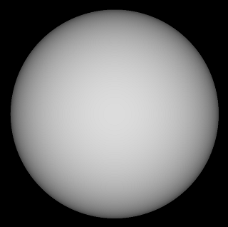
SYNTHE_SUN [X_CENTER] [Y-CENTER] [RADIUS] [WAVELENGTH] [INTENSITY]
Produce a synthetic image of the sun disk taking into account a realistic the limb darkening. The algorithm is based on the H. Neckel model (see H. Neckel, Solar Physics, 229, 13-33, 2005). The input parameters are:
(x-center, y-center) = the coordinate in pixel (and fraction)
of the disk center.
(radius) = the radius (in pixels) of the synthetic disk.
(wavelength)
= the wavelength in nanometer (the solar limb darkening is a function of wavelength).
The accepted range is between 385 nm and 1100 nm.
(intensity) = the
disk center intensity.
Typical application is a dramatic enhancement of faint contrast features on solar images, i.e. after subtraction of an observed image and the synthetic image. See the example below.
|
|
|
|
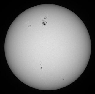
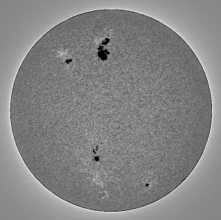
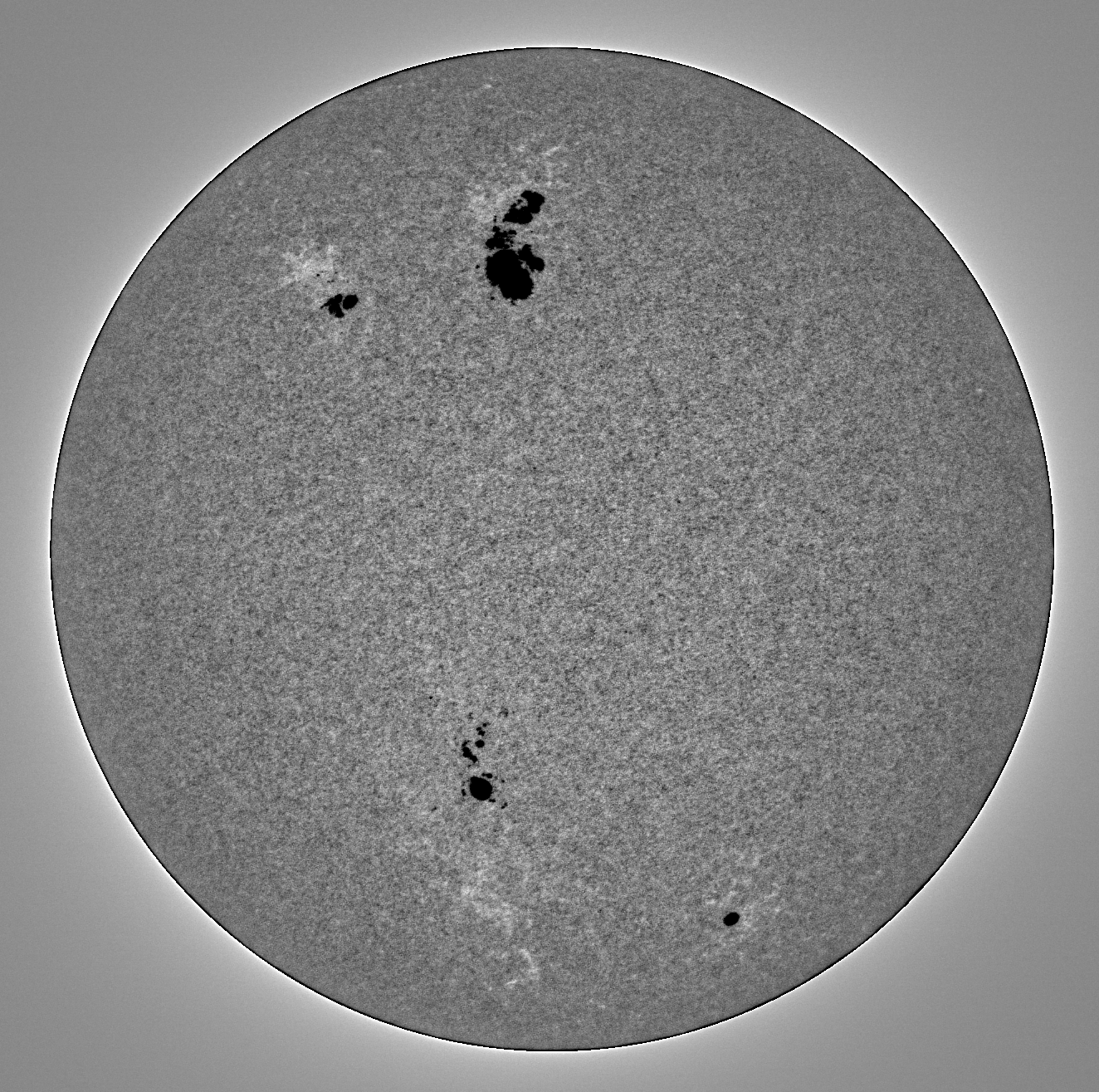
Left, a sun image taken by Valerie Desnoux July 20, 2004 (120 mm Astrophysics refractor + Nikon D70 DSRL). See here for details about these observation (a top of Pic du Midi observatory). The measured center of the disk is X=665.7 and Y=654.0. The radius of the disk is 604.8 pixels (the commands CIRCLE or CIRCLE2 are usefull for these measure). The intensity near the center is of 7040 counts.
Center, the corresponding synthetic image for the wavelength 490 nm (try and error method is here the best solution for select the optimal wavelength because the band pass of the DSRL is very large). The command used is
>synthe_sun 665.7 654.0 604.8 490 7040
Right, the difference of the observed image and the model displayed with a very hight contrast. Faint faculae are now clearly visibles. Many small sunspots are also detected on the difference image. The visualization of sun granulation in also improved. The full content of solar images is now revelated!
Click here for download the the original disk image (full resolution). Click here for download the difference image image (limb darkening removed).
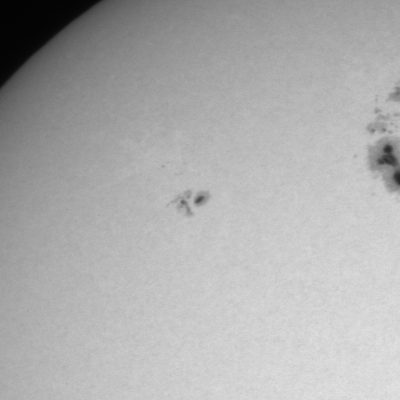
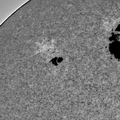
|
|
|
Left, crop of the original image. Right, same crop after subtraction of the Sun model. Numerous details are revelated.
Remenber to suppress the offset before use the SYNTHE_SUN command. Linear response of the detector is also mandatory (for example JPEG file are not useable).
WINDOW5 [X-SIZE] [Y-SIZE]
Crop area of size (x-size) x (y-size) centered on the current selection rectangle (use the mouse pointer, see also WINDOW3 command).