ASTROMETRY -
PHOTOMETRY TUTORIAL
Astrometry allows you to determine
true coordinates of objects (i.e. right ascension and declination) from their
apparent position in an image (i.e. x,y). Iris can perform such transformations. The software contain
sophisticated tools for quickly measuring the magnitude and position of asteroids,
comets,... or estimating magnitudes of celestial objects.
In order to do that, it is necessary to get a
few reference stars with precisely known sky coordinates. In Iris, these positions may
be obtained from information contained in different sources:
- The CD-ROMs of the GSC (Guide Star Catalogue,
produced by the Space Telescope Science Institute). There is one CD-ROM
for each hemisphere. This catalogue was first produced for providing the
Hubble Space Telescope with guide stars that would allow the telescope to
be stabilized during long exposures. The catalogue contains more than 15
million stars down to magnitude 16. The precision of the star position is
much better than 1 arc-second.
- The QMiPS32 CD-ROM. It contain in a simple
CD-ROM all the GSC in an optimal compressed form.
- The USNO-A CD-ROM. The catalogue contain
stars down to magnitude 19. The surface distribution of stars on the sky
is uniform but very many stars by magnitude class are absents. This is a
big problem for field identification.
- The MicroCat CD-ROM. This is a special CD-ROM
compiled by Alain Klotz for the Audine project (Aude association). It contains
selection of stars from the Tycho, GSC and USNO (full version). It is complete
from magnitude -1 to magnitude 15.8 (all stars included) and from declinaison
+90° to -45°. This is the more powerful in one CD-ROM form catalogue
of stars available today (realistic sky map, no gap between magnitude class,
astrometric precision).
We take an example for demonstrate capacity of
Iris
in the Astrometric/Photometric applications.
Download the file N2320.ZIP, decompress the image N2320.FIT and display:
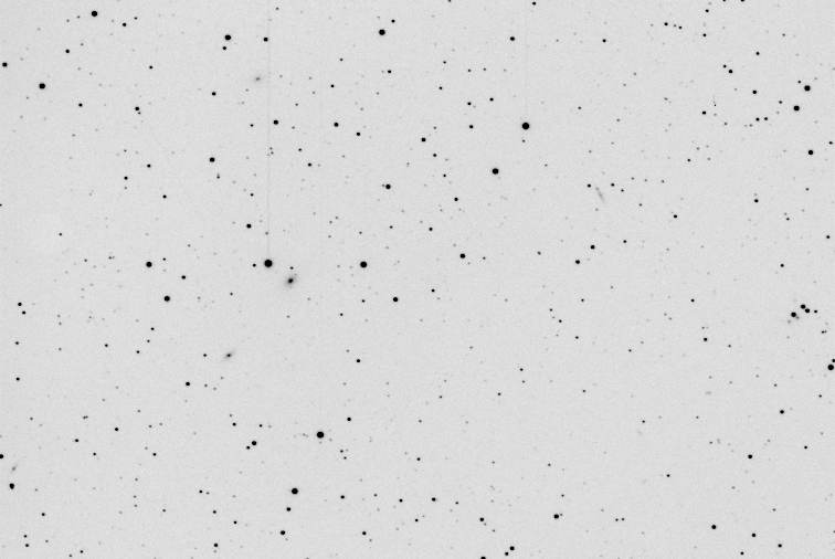
Image of the field of
the galaxy NGC 2320 (the supernova 2000B is present in the image). Instrumentation:
Takahashi FSQ-106 refractor (F=530mm) and Audine CCD camera with KAF-401E chip.
The result is the simple sum of 4 x 60 seconds exposure (240 seconds cumulative
integration time) in binning 1x1 (pixel of 9 microns). The observation was made
in Toulouse (France) and a very polluted sky. Note that the image is not flat-fielded.
The equatorial coordinates of the center of the
image are:
RA = 7 h 05 m
DEC = +50° 36'
Activate the dialog box Astrometry/Photometry...
from the Data base menu:
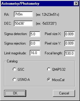
The automatic Astrometry/Photometry
dialog box of Iris.
Complete the item's of this dialog box:
RA & DEC
: approximate coordinates of the field center (a precision of 1' is sufficient
here for the algorithm to work properly). Note the format form (HHhMMmSSs for
RA and DDdMM'SS" for DEC). For the example we have RA=7h05m and DEC=50d36'.
Pixel size X & Pixel size Y: respectively the horizontal and vertical pixel size.
Here 9 microns for each side or 0.009 millimeters.
Focal length
: the focal length of the telescope. Note that the pixel size and the focal
length have to be given with the same scale, e.g. in millimeters. For the example
we have F=530 mm.
Sigma detection : coefficient that define the detection level of stars in the in
memory image. The procedure detects stars with a level greater than Sigma detection
times the noise level s in the background. If Sigma
detection is too low, the number of detected
stars may be much larger than the number of stars in the catalogue, which may
give wrong matching. In the other hand, if Sigma
detection is too high, the number of
detected stars will be perhaps too low to allow a good matching. Typically we
choose Sigma detection between 5 and 10 (detection of stars at 5s to 10s).
Sigma rejection : this is a coefficient used to removes detected stars for which the
position difference between the observed and calculated data (O-C) is greater
than Sigma rejection times the standard deviation of the (O-C) distribution (two pass
analysis). It is very useful in some case to eliminate uncertain reference stars
when making an astrometic analysis. Generally, Sigma
rejection should be between 1.5 &
3 (avoid to eliminate too many stars with very low Sigma rejection values).
But if Sigma rejection=0 where is no rejection and this is a correct option for
standard situation.
Magnitude :
only for MicroCat catalogue. This is the limit magnitude of stars extracted
from the catalogue. Here we select Magnitude=16, the fainter stars of MicroCat.
Finally, select the catalogue, MicroCat in this
example (insert the CD-ROM in your unit!). Then click the OK button. After some seconds
we have the result:
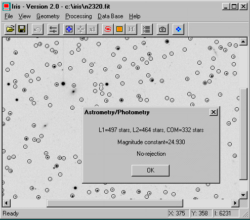
The encircled stars are
detected automaticaly (this is equivalent to the FIND_STAR command). Note that satured stars and very faint stars
are not selected.
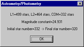
Iris
detect 497 stars in the input image (L1 list), 464 in the same MicroCat field
(L2 list ). Then, Iris searches for common stars between the MicroCat map (or
GSC, USNO maps) and the detected stars in the input image (matching operation).
Here we have common 332 stars (COM list). Iris computes the 2nd-degree polynoms that links the two
maps. Finaly Iris computes the astrometric and photometric analysis of all detected
stars. The result will be in the file STAR.LST that is automatically created.
The software return also the magnitude constant of the image (a one ADU intensity
star is of magnitude 24.93).
Some files are created in the working directory
(ASCII format - edit with a word processing):
STAR.LST file: characteristics of detected stars in the images. Each line contains
the following information:
- star number,
- X coordinate of the star in the image (decimal
form),
- Y coordinate of the star in the image (decimal
form),
- instrumental magnitude of the star,
- astrometric right ascension (in decimal
degrees),
- declination (in decimal degrees),
- true reduced magnitude (be careful, the
GSC or USNO ar NOT photometrics catalogue),
- isolation criteria for the star (1 is the
most isolated),
- the FWHM along X & Y axis.
POLX.POL & POLY.POL files: contains the coefficients of the polynoms (degree 2) and many
more informations that were used to calibrate the two fields both astrometically
and photometrically. The 14 first lines of a .POL file contain the coefficients
of the polynoms. The 15th line contains the correlation coefficient. The lines
16 to 19 contain the coordinates of the image window used for the computation.
The 20th corresponds to the degree of the polynom. The 21st line is the magnitude
constant. At last, lines 22 & 23 contain the equatorial coordinates (in
decimal degrees) of the center of the image.
ERROR_X.LST & ERROR_Y.LST files: they contain deviations from measured and calculated
equatorial coordinates (respectively for AD and DEC) in the common list stars.
This may allow you to detect pointing mistakes, or other problems (e.g. stars
with high rate proper movement).
XY.LST & EQ.LST files : the lists of common stars between detected in the input image
and the catalogue (respectively in cartesian coordinates and equatorial coordinates).
CATALOG.FIT
: an image of the catalogue field.
Now that you can have the precise equatorial
coordinates of any stars within the image. This is done with the COMPUTE command. To use this command, first define a small rectangle around
the star you want to measure, then, type from the console (no parameters):
COMPUTE
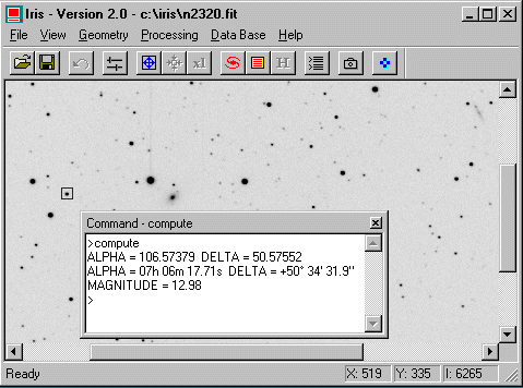
Iris COMPUTE
command execute automatically the PSF
command (see contextual menu), this give X,Y coordinates of the star, then compute
astrometric equatorial coordinates and approximate V magnitude. Select an other
star, re-execute COMPUTE command, and so on.
The command REC2SKY
compute the equatorial coordinates of any point in the image. The format of
the command is:
REC2SKY [X] [Y]
[X] and [Y] are the coordinates of the pixel
where you want to know the equatorial coordinates. In case of a star, x &
y may come for example for the PSF command (contextual menu).
For example, to determine the celestial coordinates
of a star which is near the Cartesian coordinates (166.747, 255.477):
REC2SKY 166.747 255.477
There is a symmetric command to REC2SKY, namely SKY2REC.
It will give the approximate image coordinates from the known equatorial coordinates.
This is for example useful when one wants to localize an asteroid or a comet
on an image. Note that SKY2REC will only use degree 1 polynomials (the calculation
is not so precise that COMPUTE / REC2SKY commands and not strictely symmetric). The syntax
is:
SKY2REC [RA] [DEC]
[RA] & [DEC] are the equatorial coordinates
that are to be converted into apparent coordinates in the image.
For example:
SKY2REC 7h06m12.47s 50d34'31.9"
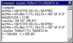
Use of the COMPUTE, REC2SKY
and SKY2REC commands.
At this point it is of course possible to use
the Sigma rejection in the Astrometry/Photometry dialog box for a more precise reduction
(not really necessary in this example):
Result of the astrometric
reduction then Sigma
rejection=3. Iris eliminate 332-320=12 bad stars before the final
astrometric calculation.
Of course you can use the GSC for the reference
catalogue. In this situation we have 170 GSC stars (L2 list) in the field of
NGC 2320. Compare to the 464 stars given by MicroCat. The later give more stars
and finaly a more precise result!
The Display
sky map... option of the menu Data base display
the sky map extracted from the used catalogue:
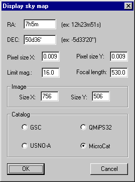
Parameters of this dialog
box are very similars to Astrometry/Photometry dialog box (AD & DEC are the
equatorial coordinate of the field center). Note the question about the image
size in pixels (this fields are automaticalled filled if an image is in memory).
The Display
sky map command will then produce an
image where stars of the selected field are represented with intensities proportional
to their magnitudes as read from the CD-ROM catalogue. You can click on a star
to obtain informations.
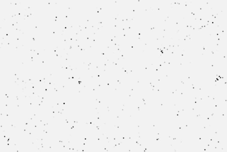
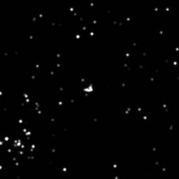
Example of image produced
by Display sky
map command and
the MicroCat catalogue. The synthetic image is very realistic (compare to the
real image N2320.FIT).
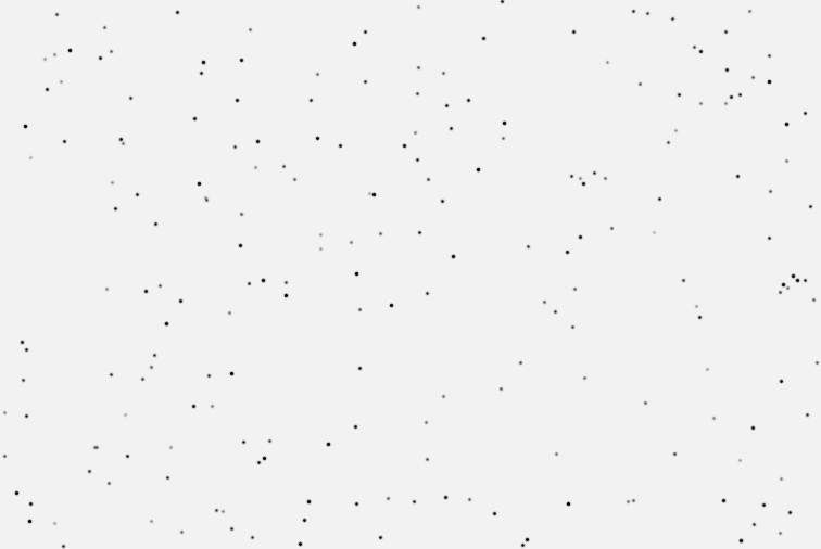
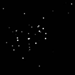
Field of NGC 2320 produced
by Display sky
map command and
the GSC catalogue.
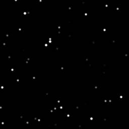
Field of NGC 2320 produced
by Display sky
map command and
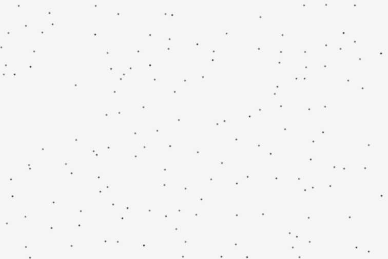
the USNO-A catalogue. The result is very difficult to interpret!
The power of
the MicroCat compilation. Simulation of a field around M45. The image size is
256x256 pixels. The pixel size is 9x9 microns. Left, the focal length of the
virtual instrument is of 5 mm and the limit magnitude is 6 (note the presence
of Hyades). Center, the focal length is of 50 mm and the limit magnitude is
8. Right, the focal length is of 500 mm and the limit magnitude is 16.
A final note. The precise measurement of the
celestial coordinates of an object has many applications: identification, proper
motion of the stars, orbit calculation of asteroids and comets, etc. Iris implements
a proven astronomical reduction technique, which is widely used in specialized
observatories. It should be clear, however, that this is not enough to produce
a quality astrometric listing. The result depends on, among other things, the
precision of the measurements of the image, the number of stars used, the accuracy
of the catalogues employed and the quality of the image. All these parameters
show that in this field, experience counts.