This window allows you to grasp the visibility of an object throughout the night or over a period of several months at a single glance, depending on which display option is used. The shortcuts ² (legend animation), & (map refresh), +, -, = (date management), s, w, e, n, a, f, h, g, z (map management), "," (contrasted stars), * (filter removal on deep sky objects) which are normaly used in the C2A main window now work in the Visibility window.
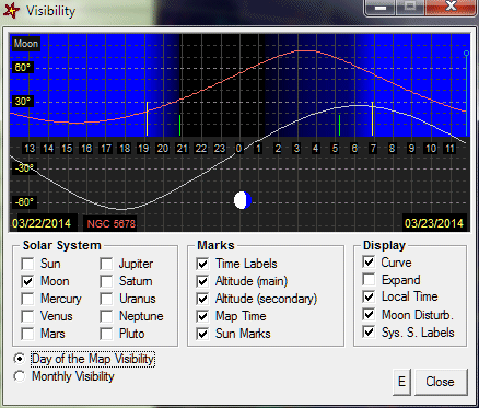
You can see hour by hour the height of an object above the horizon. The chart shows day (light blue), dusk and dawn (dark blue) and night (black). The disturbance caused by the Moon during the night period is also activated when the option Moon Disturb. is checked. When it is activated, a slightly blue background is used according to the Moon phase and height above the horizon. The respective lengths of day, night, dusk and dawn depend on the date and place currently used for the map (the visibility diagram is automatically updated when the date or place of the map change).
The visibility window can be called through the object infomation dialogue box by clicking the Visibility button, or through the contextual menu which appears when you right-click an object on the current map (then just select the “Visibility...” command).
To get more information on the components of this window, left-click on it in the image below:
The current map time is shown by a vertical bar with a small circle at the top. The onset of dusk and the end of dawn are shown by two yellow vertical lines. Similarly, the end of dusk (beginning of night) and the onset of dawn (the end of night) are shown by two small light green vertical lines. When the mous is positioned on these lines, the exact time of these events is displayed in a small popup rectangle.
When the visibility curve of the moon is requested, its phase is represented visually at the bottom of the diagram. The name of the object whose curve is displayed (in light red) is given at the bottom left of the diagram. In the same way, the day used to calculated the visibilities is indicated at the bottom right of the diagram. Note that when the time of the current map passes local noon, the next day is used to calculate visibilities.
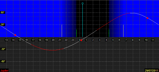
When the display of Jupiter's visibility curve is requested, C2A adds on the curve the visibility periods of the Great Red Spot (GRS) under the form of a light gray line. The GRS transit on the meridian facing Earth is spotted with small red disks. This feature lets you figure out easily at which times the GRS will be visible. It must be noted that this feature requires to know the current longitude of the Great Red Sport with respect to the System II reference. This longitude slowly change over time, and it must be updated in the advanced options of the SolSys tab of the Options dialogue box. The site http://jupos.privat.t-online.de/rGrs.htm provides a graphic that shows the evolution of the GRS longitude over time. The screen shot below shows the visibility periods of the GRS on the 29th of July, 2011:
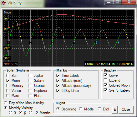
In this view, the visibility curve of the object is shown over a period of 3, 6 or 12 months (according to the selected option) at the beginning, middle or end of the night (again according to the selected option). The beginning of the night is taken 1h30 after the Sun set for the considered date, and the end of the night is taken 1h30 before the Sun rise. If the visibility curve of the Moon is displayed in the same diagram, and if the option Colored Moon is selected, the tool shows the periods at which the Moon is disturbing for observations using a color code: red for an almost full Moon, yellow for a Moon with a phase greater than 90%, a changing gray color from white (90% phase) to dark gray (30% phase), and finally green if the Moon has a phase lower than 30%. It is advised to make the view bigger (option Expand) in order to better see the different periods.
To get more information on the components of this window, left-click on it in the image below: